Click here to view map full screen.
Day two got us into the Sawtooth National Forest in Idaho. We camped at Elks Flat Campground, the place was almost empty, only three other campers at the far end of the campground. It was early in the season and they weren't charging a fee yet :). The campground is located along the banks of the South Fork Boise River. I had planned a hike on a nearby trail. After driving up and down through a private cabin area we finally found the trailhead with a closed sign because of wildfires last year. A short distance away was a gated forest road that paralleled the river so off we went. After walking on the road for awhile we turned off and started up the hill. With no brush to speak of, the only challenge was finding a route that wasn't too steep. Nice walk/climb before dinner. On the next morning's dog walk, I noticed fog or steam just on the other side of the river. It turned out that there are several little hot springs on the side of the hill and they flow into the river. Here's an estimate of the hike in Google Maps.
Our hike up the ridge


Some fire damage

Hot springs flowing into the river.

Elks Flat Campground

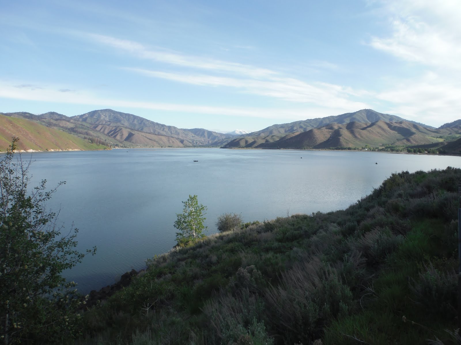
The road to the campground offered some great views of Anderson Ranch Reservoir. The campground is about five miles past the far end of the reservoir.
The next stop was Utah Lake State Park in Provo Utah. I used Google to search for what looked like the only site with a shade tree and made a reservation so we could get there later in the day. When we arrived the site wasn't available because of a fallen tree, however, we ended up getting a better spot with a row of trees that blocked the afternoon sun. We took a walk on a pleasant paved trail just outside the campground, it follows the lake for three quarters of a mile or so. Another trail, just outside the park, is the Provo River Pkwy, it follows the Provo River for miles, also paved.
Utah Lake Shore Line Trail

We got up at o'dark thirty and drove like crazy to Zion to get a campsite in the "no reservation" campground. When we arrived at Zion, there were two big lines of cars at the gate, of course I got in the line that wasn't moving. Just before we got to the gate, they put out the campground full sign. There are two campgrounds at the main entrance. The Watchman Campground is reservation only and the South Campground is first-come, first-served. When I was making my trip plans all the sites were already reserved for many months after my planned dates. Should have been looking a year in advance.
Fortunately, there is "parking lot" style RV park just outside the gate. We stayed there the night and then started driving around the South Campground a little after 6:00 AM. I spotted a father and son packing up, verified they were leaving and then signed up for the site. Great spot on an outside loop with plenty of distance from the adjoining sites.
Dogs are limited to one paved trail that runs along the Virgin River. We walked that trail several times the first two days. The third and fourth days the dogs played at Doggy Dude Ranch, just a few miles outside the park, while I hiked in Zion (separate post). I highly recommend Doggy Dude Ranch. The weather at Zion ranged from cold and rainy to hot and sunny.
Walking the 1.4 mile Pa'rus Trail along the Virgin River.


Checking out the deer across an open area from the campsite.


After Zion, we headed to Kodachrome Basin State Park. The route to Kodachrome goes by the turn off for Bryce Canyon, we didn't stop there because the dogs would have been limited to the parking lot. We also passed through Red Canyon and did a little dog walk from the Thunder Mountain Trailhead at the start of the canyon. This is a very nice area and should be included in a future trip.
Red Canyon

Kodachrome Basin State Park allows leashed dogs on the trails. We did a cloudy, sometimes windy, sometimes raining hike for about four hours. The dogs loved it. Kodachrome Basin Google Maps link.
The campground had a little store and half a dozen rental cabins.


View from our campsite after the weather cleared.

Next stop was the Chriss Lake trailhead. After a close look in Google Maps and my Garmin map, it looked like there was a spot that we could bushwhack for a short distance and hit another trail to make a loop. So with the route loaded into the GPS we started up the trail. Within 20 minutes we hit a little snow on the trail then it started a rain snow mix that turned to snow and then the thunder started. Very loud thunder that sounded just overhead. After the thunder stopped the boys went off leash. Chriss Lake loop Google Maps link.

This is not a well traveled groomed trail, it started to get a little difficult to follow the trail with it covered by snow. Thankfully it stopped snowing with only about an inch of new snow. I lost the trail a few times but was able to find it again with the help of the GPS.

I didn't know it at the time I planned the hike, but part of our loop took us on the Great Western Trail. It runs from Canada to Mexico. Here's the Wikipedia link.


The trail became very muddy and I decided to try bushwhacking early to cut back over to the trail we came up,. It looked like an easy route on the GPS and the terrain was fairly open. It didn't take too long to run into downed trees, branches, sticker bushes, creeks, swampy areas and steep hills. We did eventually make it back to the trailhead to complete the loop although nowhere near the planned route.
We continued down the road a few miles and stopped at Pine Creek campground for the night. This is one of several little campgrounds in the area. Again, it was early enough in the season that we didn't have to pay.
Pine Creek Campground

From Pine Creek we continued to drive scenic two lane roads to Wasatch Mountain State Park which is on the other side of the mountains from Salt Lake City. The park has a big campground and only a few people were there. One of the park staff directed us to a trail that heads up the ridge from the campground, they said it would go to an overlook and would be a good hike for the dogs. The overlook was only about a mile, so we kept going. Started back when it was getting time for dinner. No heavy pack (or GPS) so it was a fast paced hike. After being stuck in the camper all day, the boys enjoyed the hike. Probably hiked eight miles.
Looking down on the campground. The top of the camper is just barely visible near the center of the picture.

Our next stop was supposed to be back at Emigrant Springs State Park in Oregon. Unfortunately the camper van died soon after we entered Oregon. Well not completely, but it would only go about 50 mph on the flat, trying to go faster would result in the engine shaking violently. Oil consumption went up to 75 miles for a quart of oil (no leaks and I couldn't see any smoke ???). We made it to Hilgard Junction State Park for our last night on the road and the van made it all the home the next day. Blue's Mobile is no more, it did not seem worth $6,500 + for a new engine.
pub 3/25/2016
No comments:
Post a Comment